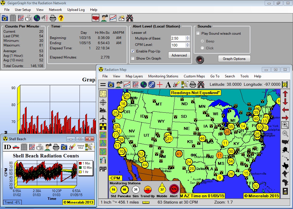
This program, which gives one access to our wildly popular Radiation Network, is a more powerful version of GeigerGraph, with all of the features of the Standard version, but with the additional capability to share Radiation data in real time over the Internet, and to monitor that data through a Radiation Map and a series of Remote Graphs. Here is a picture of the Main Screen, with detailed description below:

Overlaid on top of the main graph for the local Monitoring Station is a National Radiation Map, where each colored circle represents a Radiation Monitoring Station at that location on the Map. The numerical value displayed in each circle represents the Radiation Counts Per Minute (CPM) for that station during the last minute, which value updates every minute.
If any station detects a dangerous Radiation level, then an Alert symbol appears over that station, accompanied by a pop-up visual alert and an audible alert (play this Remote Alert sound file). Thus, you can see that by using this software, you can immediately know the Radiation levels in real time anywhere in the US where there is a monitoring station participating in this Network, and obtain immediate, real time notification of any dangerous Radiation level detected!!!
Meanwhile, the graph window at the lower left of the Main Screen represents the graph of a representative Remote Monitoring Station, providing minute by minute Radiation detail, as well as access to a log of the data by spreadsheet, along with detailed identification information for that station. A Remote Graph like this is readily available for every station shown on the Map.
Although the picture above shows a static map, the Radiation Map is fully interactive, with zoom capabilities, descriptions of Nuclear Sites and Monitoring Stations, additional Map Layers, including Counties, Airports, Roads, Railroads, Lakes and Rivers, and even the capability to download City Streets for your county. Plus, in keeping with the elements of a true Network, the Radiation Network software has its own Chat forum.
Other Features
Global Map: The Radiation Network is global, with Monitoring Stations in Europe, Asia, Latin America, etc, and the program includes a global map, showing all countries in the world, along with major cities, and most Nuclear Sites in those countries. This makes possible a truly universal Radiation Network, where monitoring stations can operate from any country and share their data with those in the United States, and vice versa.
GPS Enabled: The Radiation Map incorporates a GPS feature, where plugging a compatible GPS device into your computer turns your station into a mobile detection vehicle.
Applications
This Radiation Network software has three primary applications:
1.) You can become part of a growing nationwide grass roots Radiation Monitoring Network, contributing to the National Radiation Map, where that data is available to anyone in the US or the world at this web site:
2.) Or, if you are a municipal Fire Department in a large city, for instance, you could set up a network of Radiation Monitoring Stations at key locations around the city, such as harbors, piers, tunnels, bridges, airports, etc. and monitor the Radiation level at each site in real time from a central station, receiving any Radiation Alerts that may arise, so that you can take immediately action to control potential exposure. Because the Radiation Map is fully interactive, you can zoom in and keep the Map at the zoom level for just your Metropolitan Area, or zoom in further at any time down to the City Street level.
3.) Or, a Community Group could set up Radiation Monitoring Stations around a nuclear power plant, for instance. You could zoom in on the Radiation Map to just the region around the Nuclear Power Plant, showing your community group's network of monitoring stations, and even upload that Regional Map and your Graph(s) for viewing by the general population in your area.
Compatible Geiger Counters:
|
Order Radiation Network software above. The software will be issued by download. Your order will typically be processed within 1 business day. We will send Registration instructions by separate email when your order is processed.
*Station Name Selection
To use this Radiation Network software, you must submit a desired Station Name by which you would be known over the network. Examples include an Organization or Company name, your Ham Radio call sign or other handle, or a Locational reference, etc. Enter your Station Name in the field above the Add to Cart button, following these rules:
- Between 3 and 12 characters, inclusive
- Almost any combination of letters or numbers
- Can not contain any sort of punctuation (no underscores or hyphens), but can contain spaces
- Must begin with a letter, and not a number
- Avoid any name sounding profane
If you need a Data Cable, choose that also from Related Products. Note that the Inspector USB, Inspector EXP-USB, and the Digilert 200 already come with a compatible USB cable. However, the Observer brand of software that comes with the Ranger, EXP, and Digilert 200 is not compatible with the Radiation Network.


